Introduction
Technology continues to evolve rapidly, bringing advanced sensing capabilities into everyday devices. One of the most important innovations in recent years is LiDAR technology. Originally developed for scientific and industrial use, LiDAR is now integrated into smartphones, autonomous vehicles, drones, and mapping systems.
But what exactly is LiDAR? How does it work? And why is it becoming so important in modern devices?
In this guide, we will explain LiDAR technology in simple terms, explore its components, and look at how it is used in today’s smart devices.
What Is LiDAR?
LiDAR stands for Light Detection and Ranging. It is a remote sensing technology that uses laser pulses to measure distances between objects.
In simple terms, LiDAR works by:
-
Sending out tiny laser pulses
-
Measuring how long it takes for the light to bounce back
-
Calculating distance based on that time
Because light travels at a known speed, the system can accurately determine how far away an object is. This allows LiDAR to create highly detailed 3D maps of environments.
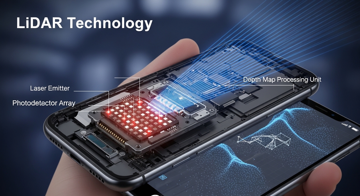
How LiDAR Technology Works
LiDAR systems rely on three main components:
1. Laser Emitter
The laser emits rapid pulses of light. These pulses are extremely short and invisible to the human eye.
2. Sensor / Receiver
The sensor detects the light that reflects back after hitting an object.
3. Processing System
A computer processes the time difference between sending and receiving the pulse. Using this data, it calculates distance and builds a digital 3D representation.
The process happens thousands — sometimes millions — of times per second, allowing LiDAR systems to generate accurate spatial models in real time.
Why LiDAR Is Important in Modern Devices
LiDAR offers several advantages compared to traditional camera-based systems:
-
High accuracy in distance measurement
-
Ability to work in low-light conditions
-
Fast real-time data processing
-
Detailed 3D environment mapping
These advantages make it ideal for applications that require precision and environmental awareness.
Common Applications of LiDAR Technology
1. Smartphones and Tablets
Some modern smartphones use LiDAR sensors to improve:
-
Augmented Reality (AR) experiences
-
Depth sensing for photography
-
Faster autofocus in low light
-
3D room scanning
LiDAR allows devices to understand spatial depth more accurately than traditional cameras alone.
2. Autonomous Vehicles
Self-driving vehicles rely on environmental awareness to operate safely. LiDAR helps by:
-
Detecting obstacles
-
Measuring distances to surrounding objects
-
Creating real-time 3D road maps
This allows vehicles to navigate complex environments more effectively.
3. Drones and Aerial Mapping
LiDAR-equipped drones are widely used for:
-
Land surveying
-
Forest analysis
-
Infrastructure inspection
-
Topographic mapping
Because LiDAR can penetrate vegetation, it can even map ground surfaces beneath tree cover.
4. Construction and Architecture
LiDAR technology is used in:
-
Building modeling
-
Site planning
-
Structural measurements
-
Renovation projects
It helps professionals create accurate digital models before construction begins.
LiDAR vs Traditional Camera Systems
While cameras capture visual images, LiDAR focuses on measuring depth and distance.
| Feature | LiDAR | Traditional Camera |
|---|---|---|
| Measures Distance | Yes | Limited |
| Works in Low Light | Yes | Less Effective |
| Creates 3D Maps | Yes | Requires software processing |
| Detects Fine Detail | Very Accurate | Visual-based only |
Both technologies often work together in modern devices to provide better results.
Advantages of LiDAR Technology
-
Precise distance measurement
-
Reliable performance in various lighting conditions
-
Fast data collection
-
Strong environmental awareness
-
Supports automation and AR systems
Limitations of LiDAR
Like any technology, LiDAR has some limitations:
-
Can increase device cost
-
Requires processing power
-
Performance may vary in heavy rain or fog
-
Not always necessary for basic applications
However, ongoing technological improvements continue to reduce these limitations.
The Future of LiDAR in Consumer Devices
LiDAR is expected to become more compact, affordable, and energy-efficient. As processing power improves, we may see wider integration in:
-
Smart home devices
-
Wearable technology
-
Robotics
-
Advanced safety systems
Its ability to create accurate 3D mapping makes it valuable for emerging technologies like mixed reality and automation.
Conclusion
LiDAR technology has moved beyond specialized scientific tools and is now part of many modern devices. By using laser pulses to measure distance and create detailed 3D maps, LiDAR enhances spatial awareness in smartphones, vehicles, drones, and other smart systems.
As innovation continues, LiDAR is likely to play an even greater role in shaping how devices interact with the physical world.
Understanding how it works helps users appreciate the technology behind many of today’s most advanced digital experiences.
Frequently Asked Questions (FAQ)
What does LiDAR stand for?
LiDAR stands for Light Detection and Ranging.
Is LiDAR safe?
Yes, consumer LiDAR systems use low-power lasers that are generally considered safe for everyday use.
Can LiDAR work in the dark?
Yes. Since it uses laser pulses instead of relying on visible light, it can operate effectively in low-light environments.
Is LiDAR better than a camera?
LiDAR and cameras serve different purposes. LiDAR measures distance accurately, while cameras capture visual details. Many modern devices combine both technologies.